Lamar Peninsula · Aransas County, Texas
Lamar, Texas
Named for a president, surveyed by an Irish Revolutionary War veteran, half-owned by Samuel Colt — and completely forgotten for thirty years before the highway brought it back.
Not That Lamar
If you searched for “Lamar Texas” and ended up at Lamar County near Paris — you’ve got the wrong Lamar. There are several Texas places carrying the name of the Republic’s second president, Mirabeau B. Lamar. The one on the map below is Lamar community on the Lamar Peninsula, in Aransas County — ten miles north of Rockport on the shores of Aransas Bay.
This Lamar was once a serious rival to Rockport and Corpus Christi. It had a customs house, a post office, a famous school, a hotel, schooner captains, and one of the most dramatic collections of early Texas characters ever assembled in one small place. By 1915 it was a ghost town. Today it’s the address of Goose Island State Park, the Big Tree, and some of the best birding on the Texas coast — and its history is almost entirely unknown outside Aransas County.
Captain James W. Byrne and the Founding (1838)
In 1838, an Irish-born veteran named James W. Byrne bought a league of land on the point overlooking Aransas Bay — the place the early settlers called Lookout Point — and laid out a townsite. He named it Lamar, in honor of his friend Mirabeau B. Lamar, then serving as president of the Republic of Texas.
Byrne’s family had fled British persecution in County Wicklow, Ireland. His sons were educated at the University of Belgium. After emigrating, Byrne fought the British again in the War of 1812. He came to Texas through New Orleans and Refugio, survived the Battle of Goliad during the Texas Revolution, and served in the 5th, 6th, and 7th Congresses of the Republic. He married Harriet Odin, a relative of the first Catholic Bishop of Texas.
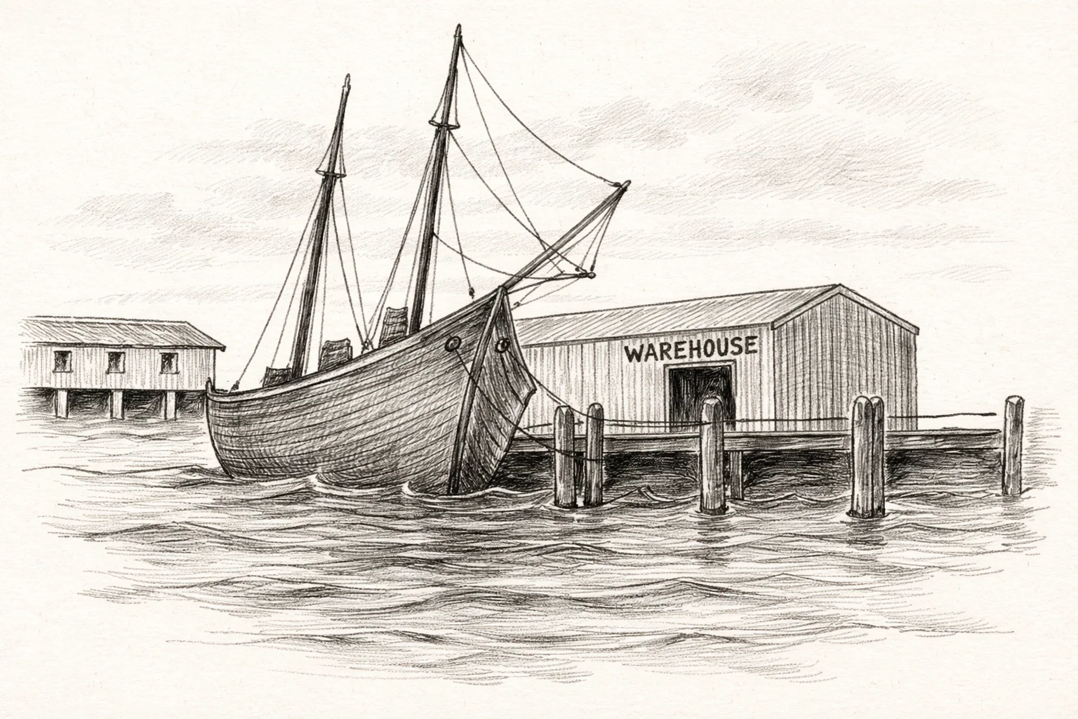
Lamar was made a port of entry in 1839 — a federal designation putting it on equal footing with Galveston and Corpus Christi for maritime commerce. The vision was ambitious: a deep-water port at the mouth of Aransas Bay, positioned to capture the trade coming through Copano Bay and challenge the ports to the north and south. The pencil drawing of Lookout Point above — sailing ships, warehouses, the bay stretching behind them — captures exactly what Byrne had in mind.
History exhibit panel — History Center for Aransas County museum collection · View Exhibits →
The Last King of Ireland’s Descendant
Byrne’s New Orleans bookkeeper was a man named Patrick O’Connor (1822–1854), a direct descendant of Roderick O’Connor, the last king of Ireland. O’Connor was married to Byrne’s niece, Jane Gregory. When Patrick was sent west for his health, he arrived in Lamar — and died within hours of getting there.
Jane came to Lamar with her infant son anyway. In 1855 she bought land on Aransas Bay and established a school. It became so well regarded that families relocated to Lamar specifically so their children could attend Mrs. O’Connor’s school.
Patrick O’Connor’s grave, marked 1822–1854, is the oldest in the Lamar Cemetery. He arrived sick, died the same day, and his wife built one of the most consequential institutions in early Aransas County. His headstone is the oldest dated marker in the cemetery.
1856 – 1862
Samuel Colt Owned Half of Lamar
TrePort — The Railroad Dream (1848–1853)
In 1848, investors with railroad ambitions briefly renamed the town “TrePort” — a deliberate echo of the English Channel port Étretat — hoping to position it as the terminus of a planned rail line. From 1848 to 1853, Lamar was officially TrePort on the maps. The railroad never came. By 1853 the name Lamar was restored.
The rival town of Aransas City, a few miles south, was fighting for the same prize: the customs house, the federal contract, the commerce. Lamar won the customs house; Aransas City eventually won the future. Both towns are ghosts now.
Stella Maris — Star of the Sea (1854)
The oldest structure in Aransas County was built in Lamar in 1858. Stella Maris — Star of the Sea — is a small Catholic chapel whose construction reads like a roll call of the founding families: James Byrne gave the land on Aransas Bay; the family of Irish empresario James Power supplied the shellcrete; French carpenter John D’Abadie designed it; and the work included Moses Ballou, an enslaved person who helped build it.
The chapel was originally built on the bayfront. In 1986 it was moved to its current location on Hagy Drive, across from the Lamar Cemetery — where it still stands today. Mass is still held there. It predates everything else standing in the county by decades, and it does not get nearly the attention it deserves.
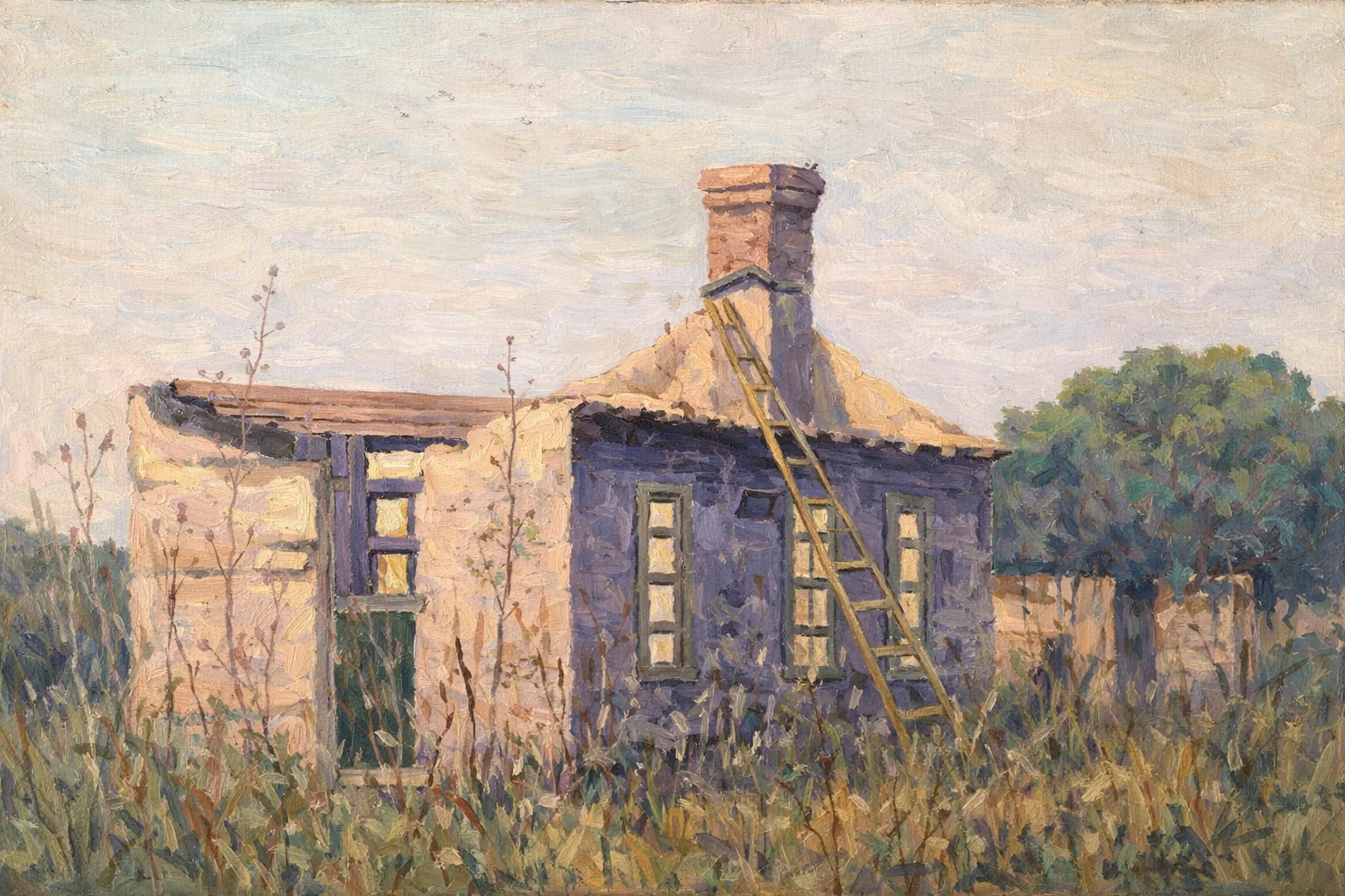
The Bunker House on Front Street, Lamar — a shellcrete structure from the town’s commercial era. Oil painting recreation based on a 1930s photograph.
Civil War, Salt Works, and Federal Raids
During the Civil War, Lamar was a Confederate salt production site — a critical wartime resource along the Texas coast. On February 11, 1864, Union troops sacked the town. The date is recorded on the 1936 state historical marker still standing on Bois D’Arc Road. Harriet Odin Byrne died in Lamar in 1858; Captain Byrne himself in 1865.
Byrne left his interests in Lamar to his granddaughter, Anna Willie Byrne Vineyard. Mrs. Vineyard records that Byrne had her burn 12 barrels of personal papers to keep them from Union soldiers. Whatever history was in those barrels is gone.
After the war, Lamar continued to decline. In the mid-1800s schooner captains had made it a working port: Captain James B. Wells Sr., Murdock McRae, Peter Johnson, Philip C. Paul — four sea captains are buried in the Lamar Cemetery. By the 1880s the maritime commerce was moving elsewhere.
1915
The Post Office Closes. Lamar Disappears.
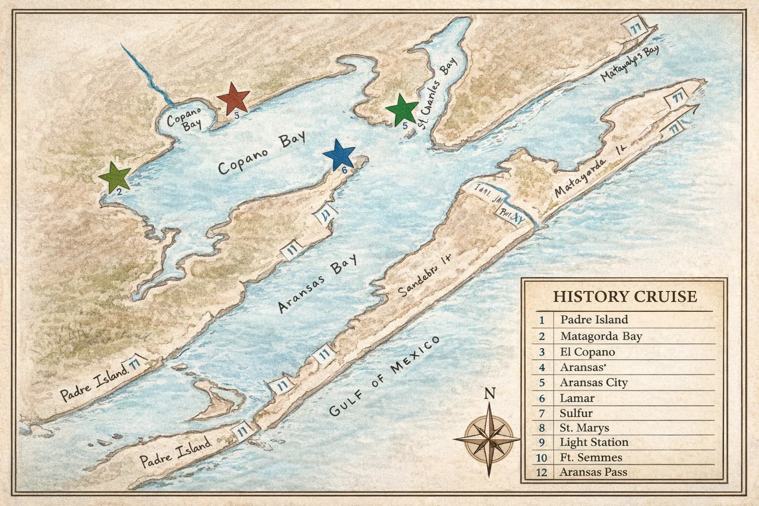
Based on Pam Stranahan’s original 2015 hand-drawn map (14 historic stops) used in the El Copano History Cruise. Courtesy Aransas County Historical Society.
The Causeway Brings It Back (1931)
In 1931, the Highway 35 causeway opened across Copano Bay, connecting the Lamar Peninsula to the mainland by paved road for the first time. The effect was immediate. Mills Wharf appeared on the water. Fishing camps opened. The peninsula — already blessed with Aransas Bay on one side and the Saint Charles Bay marshes on the other — became accessible to automobile travelers.
Captain John Mills ran the wharf after 1931 and became something of a local legend — a character in the tradition of the old schooner captains. His wharf is where the duck got an oyster permanently attached to its foot, and where Ripley’s Believe It or Not came calling. The Big Tree — a live oak on the peninsula estimated at over 1,000 years old — also earned a Ripley’s listing.
After World War II, the Kroeger family recovered the lost cemetery, cleared it, and restored it. The Lamar Cemetery Association reorganized in 1968 and received a historical marker dedicated on February 14, 1982 — attended by descendants of pioneer families from across Texas.
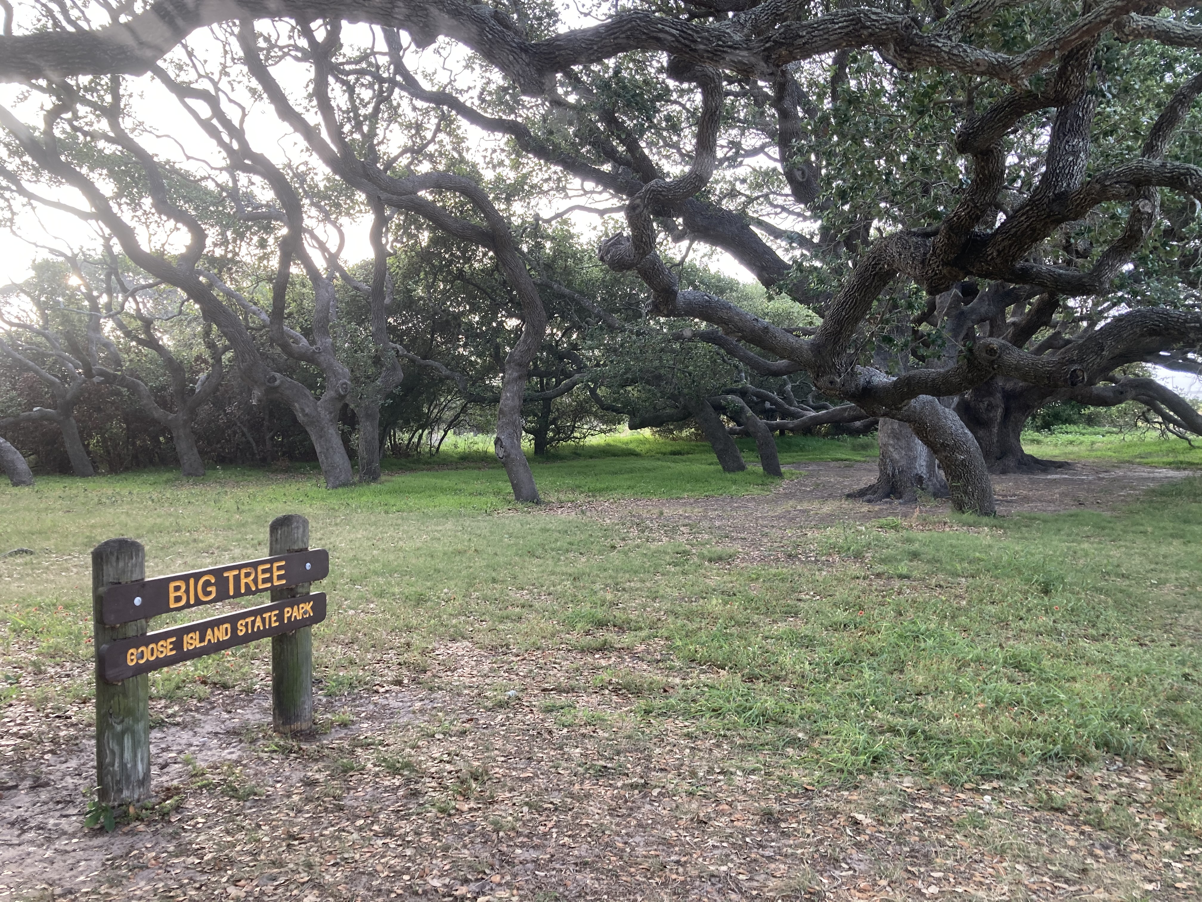
The Big Tree on the Lamar Peninsula — over 1,000 years old and a verified Ripley’s Believe It or Not entry
Lamar Today
The Lamar community today is a loose collection of homes, fishing camps, and nature preserves stretched along the peninsula between Aransas Bay and Copano Bay. Goose Island State Park sits at the tip. The Lamar Cemetery and Stella Maris Chapel stand a short drive from the park entrance, off FM 1781.
The peninsula is one of the best birding corridors on the entire Texas coast. The marshes on the Saint Charles Bay side hold reddish egrets, tricolored herons, and roseate spoonbills. The live oaks along Lamar Beach Road are a known migrant trap in spring. Whooping cranes winter in the surrounding waters.
For a place that once hosted a president’s namesake, an Irish Revolutionary War veteran, the man who invented the Colt revolver, and the last descendant of the King of Ireland — it is exceptionally quiet.
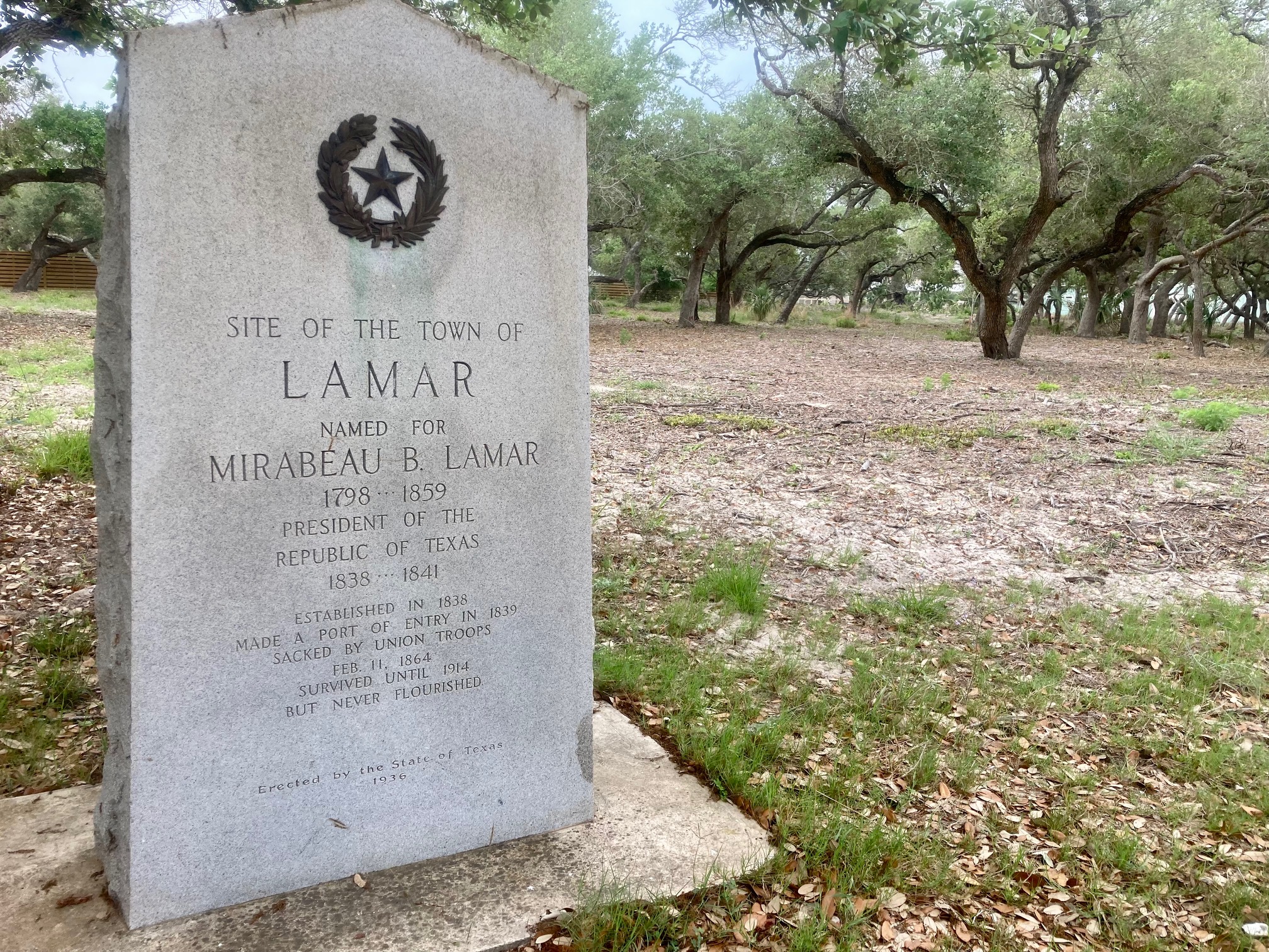
The Lamar Townsite historical marker — all that marks the location of one of the most storied communities in early Texas
The no-man’s-land marsh reserve on the Lamar Peninsula — one of the most productive birding corridors on the Texas coast
More to Explore